Cruising the Columbia River
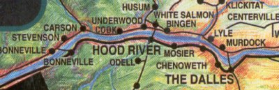
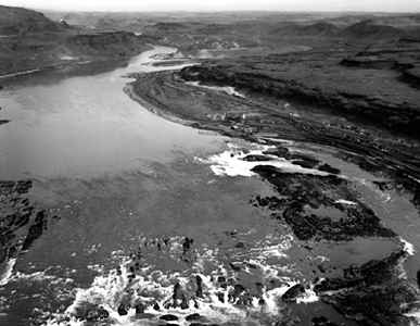
Cascade Locks to Miller IslandThe section of the Columbia river from Cascade Locks to The Dalles (rhymes with "The Gals", or just refered to as "TD") is the first portion of the river you will meet that is "harnessed" by dams, and thus above sea-level. Bonneville pool is approx. 74 feet above MSL. If you have made it to the marina at Cascade Locks, or Government Cove, you have delt with the strongest current you will encounter, as the river immediately below Bonneville Dam runs the swiftest. You are now in The Columbia River Gorge National Scenic Area. The two major towns of Hood River and The Dalles are located midway thru this Scenic Area on the Oregon side of the river. Both have public moorage facilities, as does Bingen (rhymes with Engine or better yet "Injun") on the Washington side adjacent to Hood River.
|
|
|
Just as "The Gorge" creates a "wind-tunnel" for windsurfers (yes, they/ we're sailors too!), this same geologic phenomena is as beautiful as Princess Louisa Inlet in B.C., Canada, or the Inside Passage to Alaska. A good book on this area, such as "Cataclysm on the Columbia" dealing with the historic Ice-Age Lake Missoula floods (Brentz Floods) should be part of any cruisers library traversing this section of water. You might as well read some Lewis and Clark while you are at it. |
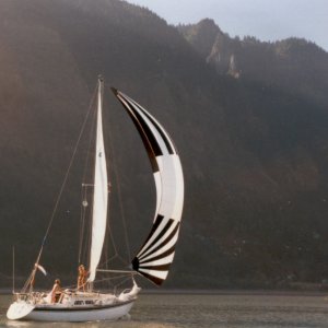 The requisite photo of our sailboat in The Gorge.. |
|
Beautiful shear cliffs and mountains rise from the waters edge, to nearly one mile vertically in places. Traversing the Cascade Mountains on a boat is a pleasure few enjoy, and to hurry through would be a shame. Take time to stop and visit the town of Cascade Locks, Hood River, Bingen and The Dalles. Watch for the Bald Eagles who nest in the cliffs.... enjoy the ride! I'll divide this into four sections; But let's first talk about the: WINDRight away, as that is the element that intimidates and attracts most folks in this stretch of the river. It also unneccessarily keeps most boaters away. Yes, it can blow. From late April until mid-September, westerlies are the prevailing wind direction. The other times of the year, it's easterlies (from the east) that prevail. But the wind ISN'T something that should keep you away! Sure, the racers who run from Cascade Locks to Hood River during the Hood River Regatta (Memorial Day) can expect broaching, exploded Kites, and general mayhem, but it CAN be a pleasent downwind sail. Just tuck a reef or two, and sit back!Wind Facts; Fact #1: It can get windy! (35 knots sometimes but rarely!) Fact #2: The wind does calm down regularly. So you can sail or motor when the wind dies down, and it does die down almost daily. A typical wind cycle during the summer is westerlies during the day,
with it dying down in the evening. Since it is the hot air rising (thermals)
in the desert out east that makes this place crank (blow) by sucking
relatively cool marine air thru the gorge, this phenomenia settles down
until the next day, baring low pressure systems coming onshore. The
wind will blow the hardest from about 1000 hrs. until 1900 hrs. (In
the fall and winter when easterlies prevail, the winds are blowing the
hardest from the east at daybreak, and ease up around 1300 hrs.) So,
if you don't want to fight headwinds, or a stiff following breeze, travel
during these low wind hours. Or sail with the small stuff hanked on
or rolled out. As a general rule, the narrower the gorge or river, the higher the wind velocity and thusly the larger the chop/swell. These areas (proceeding west to east) are;
Because of the natural formation of the gorge in these areas, the wind will be stronger than in other areas of the gorge. If, in summer, you see few or no windsurfers, the going will be smooth. Windsurfers come out at about 13-15 knots of windspeed. One tip worth remembering is to listen to the local windsurfing Wind Forecast aired daily in the summer on 104.5 FM every half hour, starting about 7:00 am or so and continuing until about 10:00 a.m.. This is a REAL DETAILED WIND REPORT and shouldn't be missed, if only for the local color and Boardhead-Speak heard! This is broadcast out of The Dalles, but can be heard even in Troutdale. The Hood River radio station broadcasts on 105.5 FM and also has weather and wind reports. A short note on the "Board-Heads" or windsurfers. Hood River has more windsurfers (year around too!) per capita than any other city or town on the planet. But they are a friendly and diverse group. They are usually under control and alert, and although they may seem to sail much too close to you, they can maneuver like a slot-car or go-cart, and will stay out of your way. If they hollar and yell "Starboard" at you, simply smile, tip your drink to them, and hold your course.... you are bigger. If any windsurfers look to be in trouble, and you can confirm this, you can either try to pick them up, (I've managed to do it a few times) or call the Hood River Toll Bridge on Ch. 16 for assistence and notification. There is a Patrol boat designated for rescue that they may dispatch. I believe the Hood River County Sheriff monitors C.B. channel 9 also. After a day or two of sailing here, and if the wind is blowing, you will forget all about the High Wind Stories you've been told...it's been years since any barges have been flipped in the river, or trucks blown from off of bridges...(nah, just kidding). Just be set-up to tuck a reef or two. Your Masthead-rigged sloop, or ketch CAN sail fast with just a mainsail flying!
CURRENTIn this section of the river runs from 1 to 2 knots, except in spring when it can hit 3 knots in places. The only substantial challenge the current holds for the mariner is the size of chop that can exists when the wind from the west blows into the easterly direction of the current. Chop, or swells can grow to 4-6 feet, and even larger on "Nuclear" wind days (35-42 knots), but only in a few selected areas where the current, wind and bottom conditions are all just right. Just as with wind, if the conditions are worth paying attention to, there are probably windsurfers out sailing and enjoying these areas of extreme chop/current/wind. The deepest channel on the river is generally where the extreme conditions can occur. All that is required for relative easy(er) going is to move to the edge of the channel/river. There are many times when I look out my window from work at Luhr Jensen & Sons to see a boat heading west, and getting unmercifully pounded by the big chop, making maybe 2.5 knots at best. What is wrong here is that the boat is usually in the Shipping or Barge Channel. There are, in most cases, a safe route a hundred yards to the side that is safe for navigating where the chop is less than 1/4 the size and the going is smooth! Of course consult your chart, but even within the shipping channels, conditions vary greatly. Don't be afraid to move around on the river. Just keep an eye on the depth- sounder.
NAVIGATIONNavigating on the Columbia River is as easy as connecting dots/waypoints and watching your depth-sounder. For the most part, anything that can cause damage to your boat is the shore. In shallows you can run aground into sand, or hit a submerged log, but you'd be WAY out on the fringes of the river, or not looking at your chart. The water is not tidal, but does fluctuate with the draw demands of the Bonneville and The Dalles Dams, usually not more than 2 feet during any 24 hour period, and certainly not more than 6 feet total. You will experience depths from 20 feet to more than 170 feet in places. Marinas are relatively shallow, but are generally safe for vessels with a draft of 10 feet or less. Your chart is really your best friend when it comes to navigation.There is ship traffic that ply the waters from Portland to Lewiston, ID. These are usually tugs pushing one to four barges with a total length of up to 500 feet. They travel thru the water at around 6-10 knots, and have very limited "instant" manouverability. Give 'em room! Scan channnels 9, 13, and 16, or monitor Ch. 13 for traffic info. Don't be afraid to call the tug to inform him of your intentions as they may seem to be in question to a Tug Pilot traveling downstream pushing 84,000 tons of wheat with a side/headwind towards a bridge. He'd appreciate it! They correspond ship-to-ship on ch. 13. They don't mind small talk either, as some of them live nearby (By the way, a tug and barge is still refered to as a "Tow" even though they are pushing barges! Interesting, huh?). If opening the Hood River Interstate bridge is in your travel plans, I'd suggest calling them on the telephone from Cascade Locks (Port of Hood River, Toll Bridge 1-541-386-3500) to check on their opening schedule. Heck, spend the night at the Port of Hood River Marina, and walk the 100 yards and talk to them personally! They are located on the South end of the bridge at the toll booth. There are channel markers and channel range markers that make the trip from Cascade Locks to The Dalles an easy and uneventful trip. Though you may wander between markers, be sure to pass on the channel side of all markers and buoys. Yes, it is fine to pass between Chicken Charlie Island and Oregon's I-84. It's narrow, has current, but it is deep. Just remember to pry your eyes from the cliffs once in awhile to keep on course.
ANCHORAGES/MOORING/MARINASIf you have become comfortable with the lower Columbia, where you can anchor almost anywhere, then finding a spot to splash the hook for the night is going to require more planning east of Bonneville Dam. Much of the river is exposed to current and wind, so the areas for harbour are few and far between. If you wish to have a guaranteed night of sleep tie up in a marina. If you are willing to risk losing a couple winks of sleep there are a few beautiful places to anchor overnight. Here are my recommandations, including marinas and anchorages, starting from Bonneville Dam; Cascade Locks Marina (541-374-8619) Showers, Gas, moorage,
short walk to Eastwind Cafe for the BEST soft ice cream cones! Narrow
and shallow enterance. Keep in the middle of the channel. Limited depth
to 8 feet. Government Cove 4 miles upstream on the Oregon side. Anchorage
with no services. Great protection, good holding ground, and your own
rock quarry to explore. Enter almost from due north, keeping about 15
yards off the rock jetty to the east of you. Excellent holding ground
in 8-15 feet of mud.
Bingen Marina Water, moorage and anchorage. Good walk into
town. Eat at Fidels for good Mex. food! (Great Margaritas Too). Keep
plenty of room between you and the rock on the down stream side of the
enterence. Tie up to the primitive docks, or anchor out. You might want
to lock things up here. Mayer State Park A Bomb-Proof Anchorage with a great view of
Eastern Oregon. About 6.5 feet of total draft is the maximum for this
anchorage. Line up the tall piling with the wooden fence section (about
215 degrees mag.), and come in slow. Exit the same way with frequent
back-sighting....remember there is current here. This is my favorite
anchorage. There are two mooring floats located in the anchoring basin,
but anywhere you decide to set the hook is fine. The wind can blow hard
sometimes during the night, but with only 8 feet below you, some scope
should keep you into the muddy bottom here. I've never dragged. The Dalles
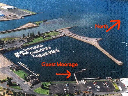
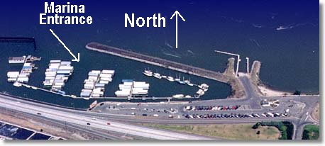
Marina (http://www.portofthedalles.com)This is a no-brainer,
as the rock jetties will only let you in at one spot. Proceed to port
and to the quest dock for water, gas, ice, showers, etc. which is run
by The Dalles Yacht Club members. For a nice walk into town and lunch,
ask for the Baldwin Saloon, next to the RR tracks on Court St. The folks
from the The Dalles Yacht Club are the nicest around! They have ice,
showers and advice that they freely offer to total strangers. All the towns along this strech of the river are within easy walking distance to the marina, but I wouldn't want to carry groceries and major provisions, as it's too far for that kind of heavy hauling. The recreational river traffic here is sparse, which keeps the locals friendly towards boaters. It's small town stuff, and you are sure to be greated with enthusiasm and helpful information. From here I'd suggest continuing upstream via The Dalles Locks. The Celilo Pool is more like Baha than you can believe. Proceed up though the Celilo Railroad Bridge (Ch. 13, and the bridge tender is sitting in a office in Pasco WA.). Continue east up along the Washington shore to Miller Island, and anchor in "Full Moon Bay" on the NE corner of the island in 10 feet of water. Look for the pictographs on the rocks! Locks and Locking Through:Te order of passage through the lock seems to be at the discretion
of the lock operator. The boat arriving first usually will be locked
through first, but there are exceptions. Commercial vessels will take
precedence. Recreational vessel schedules are in effect at some locks.
Call the U.S. Army Corps of Engineers for more information or use the
following link; If you want to be a real pro, and sound like one, you should use the locks proper radio call signs below; Bonneville - WUJ 33
US Army Corps of Engineers has a terrific website that takes the mystery out of locking though, located here.
Additional Information; 2002 Locks Schedule for Rec. Vessels - Times for passage. Or click here for the Bonneville Dam and Army Corps webpage. Captains Nautical Supply - Charts, cruising guides, river info. - Call or email them to get the "Evergreen Pacific River Cruising Atlas - Columbia River". This is a terrific guide for the river. Of course it's on of those "not to be used for navigation" set of charts. Call them at 503.227.1648 to order this. Columbia and Snake Rivers - Terrific info and area links Boating Guide to the Lower Columbia and Willamette Rivers - Jointly published by the Oregon State Marine Board and a buncha other adjencies. Click on publications for boating guides and marina facilities. Most are *.pdf files. Oregon Boaters Handbook - covers Oregon's boating regulations. Using the Columbia - Snake River Inland Waterway and How to Lock Through - print this out and keep with your boat. Charts (if desired) for Portland to Umatilla (John Day
dam)
Happy Cruising, Feel free to E-mail me for additional info. |
|